Nature trails in the southern Tessin
Leaving directly from our hotel you will find a romantic and unspoiled hiking area with lush chestnut forests and rivers. More than 300 km of hiking trails connect 26 characteristic Ticino villages on the sunny slopes of the Malcantone Valley.
The attentive hiker will also repeatedly discover old charcoal burning sites where coal was produced from beech wood up to 100 years ago. Remarkable are the hidden grotti, the many dry stone walls along the way and the old chestnut trees, some of which are several hundred years old.
Miglieglia is an ideal starting point for "spontaneous hikes" that will fulfil all wishes and for countless short and day hikes. We will be pleased to provide you detailed information and maps.
Wen der Berg lockt – man aber doch nicht ganz so hoch hinaus will! Kastanienhaine, Alp Pian Böcc und Hangweiden mit ein bisschen Aussicht.
Wegbeschreibung
Vorbei an altehrwürdigen Kastanienbäumen, stets durch die Terrassierungen und auf den Schmugglerpfaden.
Wegbeschreibung
Es gibt viele schöne Wanderungen rund um Cademario. Der Schönste führt auf den Monte Cervello.
Wegbeschreibung
Auf dem Weg zur Maglio lohnt sich der Abstecher zum „Castello di Miglieglia“. Eine alte Festigungsburg aus der Römerzeit - Mystik pur!
Wegbeschreibung
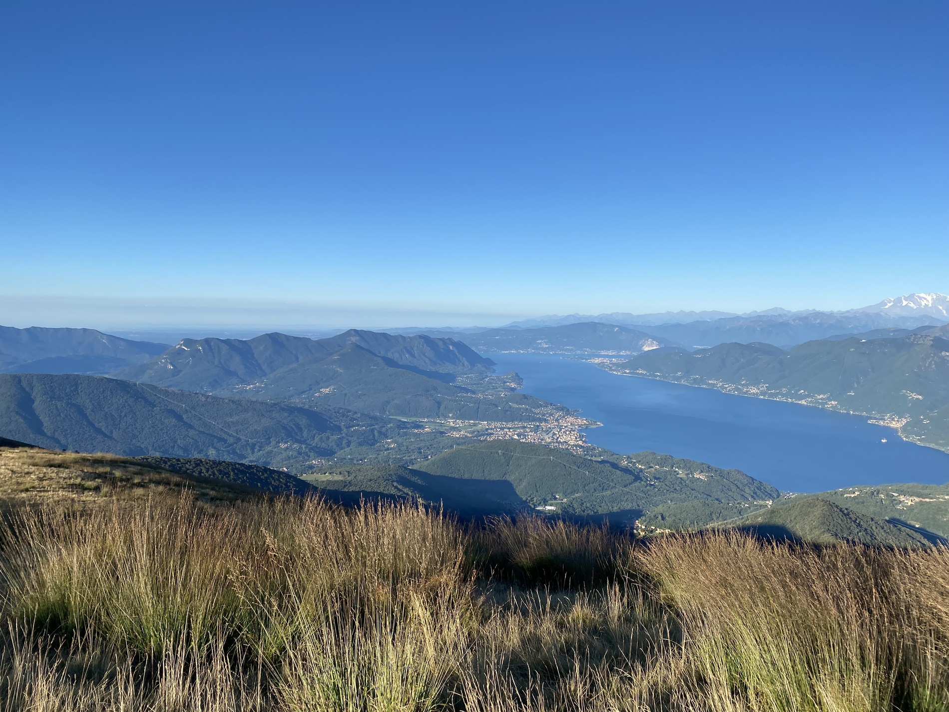
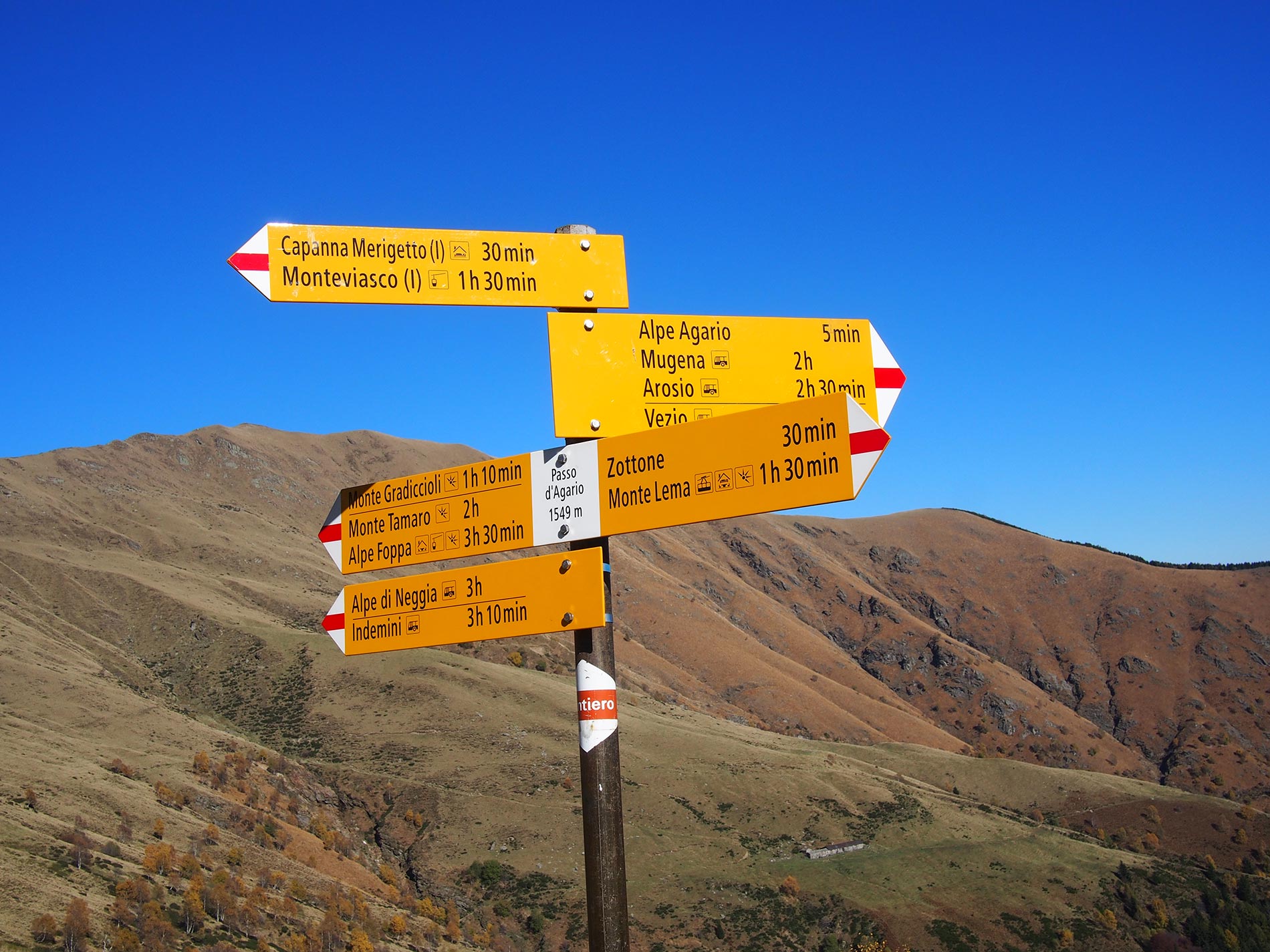
Ein alter Verbindungsweg nach Italien durch faszinierende Wälder und mit immer wieder überraschenden Ausblicken auf den Lago Maggiore. Ca. 1 Std unterhalb des Monte Lema.
Aufstiege und Abstiege zum Monte Lema, Nr. 5 zu Pradecolo
Der Themenwegweg führt durch eine bezaubernde, harmonische Landschaft, in der die Natur Ihren ganzen Reichtum entfaltet. (Im Bild oben)
Kastanienweg Broschure
Kastanienweg Wegbeschreibung
Eine gemütliche Wanderung durch die Kastanienwälder bis nach Astano. Die Zusatzschlaufe bis zur Grenze umd zum See zu kommen, lohnt sich.
Wegbeschreibung
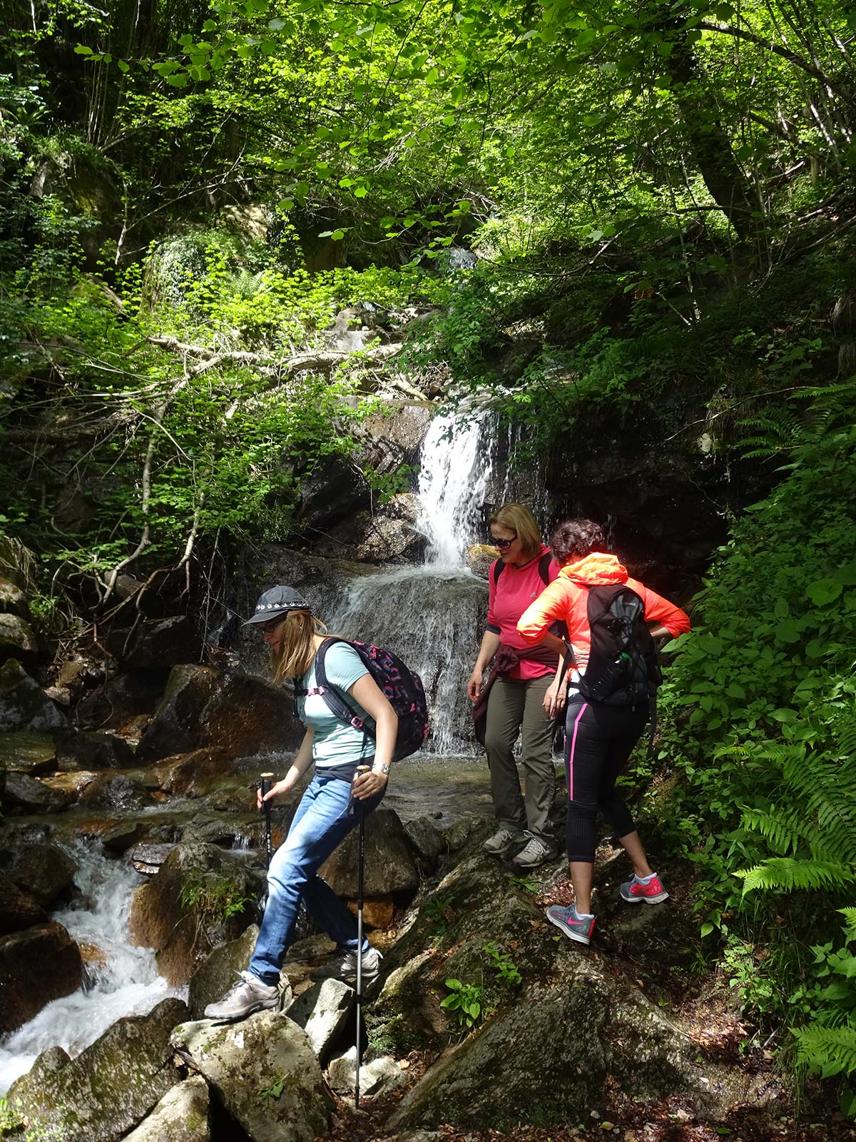
Auf geht's zum Felsenschwimmbecken und Wasserfall "Al Maglio". Die Mühle/Hammerschmiede (Maglio) kann besichtigt werden. Beim Kiosk, geführt von Paolo, Roy & Nik gibt es Kaffee, Getränke, Glace und typisches Gebäck. Geöffnet:. April – Oktober offen! Montags & bei Regen geschlossen! Tip: Ein Abstecher (ca. 15 Minuten hin und zurück) zur „Rovina del castello di Miglieglia“ lohnt sich bei jeder Variante. Eine alte Festigungsburg aus der Römerzeit!
Wegbeschreibung
Die Alp Firinescio wiederentdeckt! Ab Mai mit einer herrlichen Flora, mit gigantischem Ginster, Erika und Alpenrosen.
Wegbeschreibung
Eine schöne und neue Rundwanderung wo man zum Kastanien sammeln nicht zu kurz kommt. Es geht wie meist im Malcantone hoch und runter!
Wegbeschreibung
Kastanienkuchen oder Linzertorte... unter dem Maulbeerbaum. Ein eindrückliches Erlebnis, mit wieviel Hingabe die zwei Schwestern, Patrizia und Francesca, vorbeikommende Wanderer mit Köstlichkeiten verwöhnen, mitten in der Natur.
Wegbeschreibung
Menukarte "Ai Gelsi"
Eine atemberaubenden Aussicht, unendliche viele Wanderroten und Biketrails, Gleitschirmfliegen, Modellfliegen, eine Sternwarte und ein Restaurant mit einer grosser Terrasse. Monte Lema
Aufstiege und Abstiege vom/zum Monte Lema von Miglieglia (unsere Vorschläge)
Aufstiege und Abstiege vom/zum Monte Lema vom oberen Malcantone (unsere Vorschläge)
Alpwege auf dem Monte Lema (offizielle)
Rundwege auf dem Monte Lema (unsere Vorschläge)
Rundwege auf dem Monte Lema (offizielle)
Das Teilstück der Höhengratwanderung "Traversata" vom Monte Lema - Monte Tamaro ist begehbar. Die beiden Bergbahnen sind geöffnet!
Traversata Lema- Tamaro
Unsere Tip, nicht die ganze Gratwanderung, sondern nur das imposanteste Teilstück vom Monte Lema bis zum Passo Agario (altes Zollhäuschen) zu begehn. Von da gibt es dann mehrere sehr schöne Möglichkeiten ins Tal ab zu steigen in die Dörfer, Arosio, Mugena, Vezio oder Fescoggia und innert 10 Minuten mit dem Bus nach Miglieglia zurück zu kehren. Auch umgekehrt möglich.
Aufstiege und Abstiege vom/zum Monte Lema vom oberen Malcantone (unsere Vorschläge)
Following we will present you 8 beautifull theme paths in the Malcantone.
Theme paths
Miglieglia - Maglio di Aranno - Aranno - Novaggio - Miglieglia (4 h)
This trail leads you to the discovery of dry walls, windmills, corn grinding mills, castles, old brickworks and mines, giving everyone the opportunity of stopping for a moment to admire those simple things that in the past contributed to man’s survival and like, in the case of mines, hope for a better future.
the path of marvels (only in german)
Video
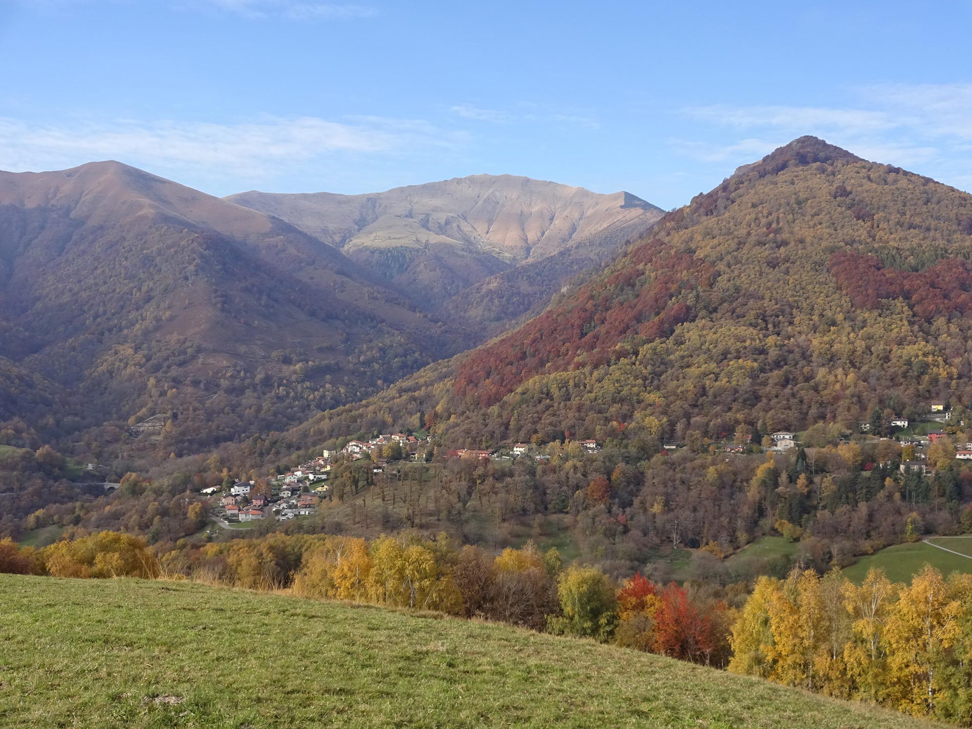
Miglieglia - Breno - Fescoggia - Vezio - Mugena - Arosio - Caroggia - Breno (4-5 h)
A Thematic path crossing five villages in the Alto Malcantone region, passing through woodlands with chestnut trees, birches, creeks and fields. Moreover, one can admire the view of the various villages and glimpse a panorama reaching until Monte Rosa.
Flyer the chestnut tree trail
Info the chestnut tree trail
Miglieglia - Sosta - Forcola - Monte Lema (3-4 h
A way of approaching nature that permits one to observe its ecosystem and understand its evolution.
Flyer Between sky and earth (only in german)
Fescoggia – “Böcc dal fer” - Breno - Ponte di Vello - Maglio (2-3 h)
In einer magischen Gegend zeigt dieser in der Schweiz einzigartige Themenweg, wie aufwändig früher der Abbau des Eisenerz bis zur Verabeitung in der Hammerschmiede vor sich ging.
Flyer from the arch mine to the maglio (only in italien)
Castelrotto - Ronco - Beride -Bearbeiten Castelrotto (2 h)
An ideal combination of culture, history and nature along the circular path that connects the picturesque villages of Castelrotto and Beride.
Flyer Man's Trace (only in german)
Molinazzo (Ramello) - Monteggio - Termine - Suino - Sessa - Ramello (2,5 h)
This itinerary aims at highlighting the tokens of past history and of the natural environment and proposes much food for thought on the relationship between man and water in the past and in the present.
Flyer the Water Trail Revisted
Caslano - Caslano (1,5 Std)
Auf diesem Naturlehrpfad lernt man unmittelbar eine hoch interessante und schützenswerte Naturlandschaft kennen. Auf kleinstem Raum ist hier eine beachtliche geologische und botanische Vielfalt vereint. Aussicht auf die Bucht von Caslano und von Agno, die Seeenge von Lavena Ponte Tresa und nach Italien.
Flyer Naturpark Monte Caslano
Arosio - Astano - Calano - Bioggio (45 Km!)Auf dieser Route können Touristen und Geniesser die schönsten Stellen im Malcantone entdecken: Eindrucksvolle Zeugnisse der Kultur und Traditionen früherer Generationen.
Flyer Sonnenuhrenweg


Cristina & Matteo
Via alla Chiesa 25, 6986 Miglieglia